Wood Island Lighthouse
Biddeford Pool, Maine
|
Location: About 2 miles east of the mouth of the Saco River
Coordinates: 43 27 25 N 70 19 45 W View Wood Island Lighthouse in a larger map Previous Lighthouse (north to south): Goat Island Light
Next Lighthouse (north to south): Cape Elizabeth Light |
Active U.S. Coast Guard aid to navigation, licensed to: Friends of Wood Island Lighthouse (a chapter of the American Lighthouse Foundation)
Accessibility: Wood Island can be reached by boat only. The island and lighthouse can be seen distantly from a walking trail at the East Point Audubon Sanctuary. It's approximately a 15-minute walk from the gate to the view of the island. Directions: Take Route 9/208 (Pool Road) south from Biddeford for five miles, turning left on 208 toward Biddeford Pool. After 0.6 miles, turn left at the T intersection, then bear right through two forks to Lester B. Orcutt Boulevard, following it to the point. The gate entrance is on the left side. Parking is permitted along the street. Dogs are not permitted in the sanctuary.
The island and lighthouse are not open to the public, except through tours run by the Friends of Wood Island Lighthouse. The Light Runner departs Vines Landing in Biddeford Pool in season. Please click here for more information. Station established: 1808
Present lighthouse built: 1839 Automated: 1986 Construction material: Stone Other buildings still standing: 1858 keeper's house, 1903 oil house, storage building Height of tower: 47 feet Height of focal plane: 71 feet Earlier optic: Fourth-order Fresnel (1858); Present optic: VLB-44/2.5 (LED) (below) 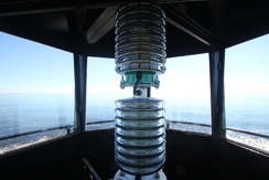
Characteristic: Alternating white and green flashes every 10 seconds.
Fog signal: Mariner Radio Activated Sound Signal (MRASS); two blasts every 30 seconds |
|