Curtis Island Lighthouse
Camden, Maine
|
Location: Entrance to Camden Harbor
Coordinates: 44 12 06 N 69 02 54 W View Curtis Island Lighthouse in a larger map |
Active U.S. Coast Guard aid to navigation.
Maintained by: Town of Camden with support from the Curtis Island Lighthouse Foundation Accessibility: The island is a public park but is accessible only by boat. The lighthouse is not open to the public. It is most easily seen from sightseeing cruises leaving Camden Harbor. It can also be seen from the "Curtis Island Overlook," on Bayview Street, just southeast of the intersection with Beacon Street. Look for the sign and the path leading to the water's edge.
Station established: 1836
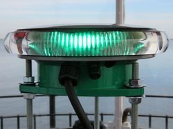
Present lighthouse built: 1896 Automated: 1972 Construction material: Brick Other buildings still standing: 1889 keeper's house, 1889 barn, 1889 boathouse, 1895 oil house Height of tower: 25 feet Height of focal plane: 52 feet Previous optic: Fourth order Fresnel lens (now at Camden Town Hall) Present optic: VLB-44 (LED), installed in January 2017 (below, photo by Bob Trapani, Jr.) Characteristic: Occulting green, four seconds (four seconds of green followed by one second of darkness)
|
Related sites
Camden Resource and Vacation Guide Penobscot Bay Regional Chamber of Commerce Maine.info: Resources for Maine Travel & Living Lobster Trail - The Lobster Trail winds along the N. Atlantic Coast, celebrating “butter soaked” options to eat, stay and play “lobster style.” |
