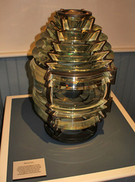
Brant Point Lighthouse
Nantucket, Massachusetts
|
Location: Entrance to harbor at Nantucket Island.
Coordinates: 41 17 24 N 70 05 25 W View Brant Point Lighthouse in a larger map |
Active aid to navigation. Accessibility: The grounds are open to the public; the lighthouse is within walking distance of the ferry landing. The tower is owned by the Coast Guard and is not open to the public.
Station established: 1746 Current tower built: 1901 Automated: 1965 Construction material: Wood Other buildings still standing: 1856 lighthouse (without lantern), 1856 keeper's house, two range light towers (1908), oil house, storage building, garage, 1936 boathouse Tower height: 26 feet Height of focal plane: 26 feet Earlier optic: Fifth-order Fresnel lens (below, now at the Nantucket Shipwreck & Lifesaving Museum) Current optic: 250 mm Characteristic: Red light eclipsed every four seconds Fog signal: One blast every 10 seconds |
|
