Perkins Island Lighthouse
Georgetown, Maine
Click here for a gallery of Perkins Island Light photos on SmugMug (prints and gift items available)
|
Location: East side of Kennebec River, about two miles from the mouth of the river
Coordinates: 43 47 12 N 69 47 06 W View Perkins Island Lighthouse in a larger map Previous lighthouse (south to north): Cuckolds Light
Next lighthouse (south to north): Squirrel Point Light |
Active U.S. Coast Guard aid to navigation The lighthouse is licensed to the American Lighthouse Foundation.
Accessibility: The tower and buildings are closed to the public. The station is best seen from sightseeing cruises in the area.
Station established: 1898
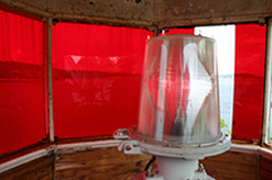
Present lighthouse built: 1898 Automated: 1959 Construction material: Wood with brick foundation Other buildings still standing: 1898 keeper's house, 1898 barn, 1901 boathouse, 1902 fog bell tower, 1906 oil house Height of tower: 23 feet Height of focal plane: 41 feet Earlier optic: 1898: lens-lantern 1902: Fifth-order Fresnel lens Present optic: 250 mm (below) Characteristic: Flashing red every 2.5 seconds with two white sectors |
|
