Bakers Island Lighthouse
Salem, Massachusetts
|
Location: North end of Baker's Island, approach to Salem Harbor
Coordinates: 42 32 11 N 70 47 09 W View Bakers Island Lighthouse in a larger map |
Managed by Essex National Heritage Commission (ENHC)
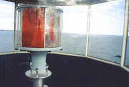
Accessibility: The lighthouse can be seen distantly from Salem Willows Park and Winter Island in Salem, and from Chandler Hovey Park on Marblehead Neck. It can also be seen from Manchester-by-the-Sea's Boardman Ave/Harbor Street loop. There are also public tours in summer. Essex Heritage offers trips aboard Naumkeag from early July to early September. Click here for details. Overnight stays are also available - click here for info. Station established: 1798 Current lighthouse tower built: 1820 Automated: 1972 Construction material: Granite Other buildings still standing: 1878 keeper's house, 1907 fog signal building, oil house, assistant keeper's house. Tower height: 59 feet Height of focal plane: 111 feet Previous optic: Fourth order Fresnel lens (1855) Present optic: VRB-25 (below) Characteristic: Alternating white and red flashes every 20 seconds (active U.S. Coast Guard aid to navigation)
Fog signal: One three-second blast every 30 seconds |
Related sites
Salem City Guide Salem Homepage |
