Baker Island Lighthouse
Islesford, Maine
More information: History / Photos / Bibliography / Cruises / Postcards
|
Location: Cranberry Islands, about 4 miles southeast of Mount Desert Island, in Acadia National Park
Coordinates: 44 14 29 N 68 11 56 W View Baker Island Lighthouse in a larger map Previous lighthouse (south to north): Mount Desert Rock Light
Next lighthouse (south to north): Bear Island Light |
Active aid to navigation. The light station buildings are now owned by the National Park Service as part of Acadia National Park. The organization Keepers of Baker Island is working for the preservation of the buildings.
Accessibility: Baker Island is reached by boat only. The Bar Harbor Whale Watch Company offers a tour of the island. The lighthouse tower is not open to the public. Station established: 1828
Present lighthouse built: 1855 Deactivated 1955-57 Relighted and automated 1957 Construction material: Brick. Other buildings still standing: 1855 keeper's house, 1895 oil house, 1905 fuel house, two storage buildings Height of tower: 43 feet Height of focal plane: 105 feet Earlier optic: Fourth-order Fresnel lens (now at the Fishermens' Museum at Pemaquid Point Lighthouse in Bristol, Maine) (below) Present optic: VLB-44 (LED) (installed June 2017) Characteristic: Flashing white every 10 seconds 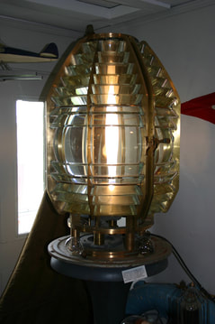
|
|