Butler Flats Lighthouse
New Bedford, Massachusetts
|
Location: New Bedford Channel , mouth of Acushnet River
Coordinates: 41 36 13.5 N 70 53 40.5 W View Butler Flats Lighthouse in a larger map |
This lighthouse is privately owned.
Accessibility: The lighthouse is not open to the public. It can be seen from the shore along East Rodney French Boulevard, and from the ferries leaving New Bedford for Martha's Vineyard and Cuttyhunk.
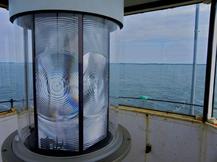
Station established: 1898 Current lighthouse tower built: 1898 Automated: 1978 Deactivated: 2014 Construction material: Brick, cast iron Tower height: 53 feet Height of focal plane: 53 feet Original optic: Fifth-order Fresnel lens Present optic: LED (below) |
|
