Boon Island Lighthouse
York, Maine
More information: History / Photos / Bibliography / Cruises / Postcards
|
Location: About 6 miles east southeast of Cape Neddick
Coordinates: 43 07 18 N 70 28 36 W View Boon Island Lighthouse in a larger map |
Active U.S. Coast Guard aid to navigation; owned by Boon Island LLC.
The lighthouse is not open to the public. It can be seen distantly from points along the shore, including Long Sands Beach and Sohier Park in York, but it is best seen by boat.
Station established: 1799 (day beacon), 1811 (lighthouse)
Present lighthouse built: 1855 Automated: 1978 Construction material: Granite Other buildings still standing: generator building Height of tower: 133 feet Height of focal plane: 137 feet Earlier optic: Second-order Fresnel lens Present optic: VLB-44 (LED, solar powered. Installed in 2016.) (Below) 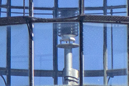
Characteristic: Flashing white every five seconds
Fog signal: One blast every 10 seconds |
Related Sites:
Alexander Parris Digital Project Maine.info: Resources for Maine Travel & Living Lobster Trail - The Lobster Trail winds along the N. Atlantic Coast, celebrating “butter soaked” options to eat, stay and play “lobster style.” |